Buscar
-

6 Healthcare Action Items for the LGBTQIA+ Community
© Niyazz via Canva.com Every patient, regardless of how they may identify, greatly benefits from preventive healthcare and early detection. Members of the LGBTQIA+ community face unique considerations when it comes to their health, and a proactive approach to preventive screenings and vaccines is important in order to address their individual health needs. Dr. Karen Thiele, Family Medicine Physician with University Health and Assistant Professor of Family and Community Medicine at the University of Nevada, Reno School of Medicine, breaks down key steps that LGBTQIA+ patients should take to safeguard their health. PrEP and PEP Pre-exposure prophylaxis (PrEP) is a strategy to prevent human immunodeficiency virus (HIV) infection. It is an important measure for those who are HIV-negative but may be at risk of contracting it. The highest risk sexual practice is receptive anal intercourse, due to the relative fragility of rectal tissue. This medication can stop HIV from spreading in the body and help patients maintain their HIV-negative status. PrEP is available in both pill form, which is taken every day, and injection form, of which the first two injections are initiated one month after another while all other injections are initiated every two months. Post-exposure prophylaxis (PEP) is an antiretroviral drug regimen taken after potential HIV exposure to prevent an HIV-negative individual from converting to HIV-positive status. PEP is only for emergency situations and must be started within 72 hours of exposure – sooner is always better than later – and must be taken for 28 days. PrEP and PEP are available in many ways, including visiting your primary care provider (PCP) or an urgent care location. HPV Immunization All genders and identities can protect themselves against human papillomavirus (HPV), a sexually transmitted infection (STI) that can lead to the risk of cervical, mouth, head, neck, throat, anal, vaginal, penile and vulvar cancers. HPV is so common that nearly all sexually active people, regardless of sexual orientation and practices, will be exposed at some point in their lifetime. The HPV vaccine (common brands include Gardasil and Cervarix) is a safe and effective method to prevent HPV, according to the Centers for Disease Control and Prevention (CDC). This vaccine protects against infections that can lead to HPV-related cancers and precancers, as well as genital warts. While patients should start receiving the vaccine at 9 years old years old, unvaccinated adults up to the age of 45 can also receive the vaccine through their PCP – better late than never! STI Testing Sexually-transmitted infections form from bacteria, viruses or parasites that can be transmitted by person-to-person sexual contact through semen, vaginal, blood and other bodily fluids. According to the U.S. Department of Health and Human Services, there are more than 20 million estimated new STI cases across the nation each year. Luckily, most STIs are preventable. Annual STI testing for HIV, gonorrhea, chlamydia and syphilis is important to stay on top of your sexual health. Because these STIs may sometimes have no symptoms, screening is recommended regularly and with any change in sexual partners. Depending on the specific condition, tests for these infections include urine, swab and blood tests. Speak with your primary care provider on a screening schedule that works best for you. Prostate Exams Prostate exams look for early signs of prostate cancer in patients who still have a prostate. The CDC recommends those who are at least 55 years old get regular prostate screenings; however, for patients with a family history of prostate cancer, screenings may be recommended as early as 45 years old. These exams are done via two common methods – a prostate specific antigen (PSA) blood test and a digital rectal examination (DRE). Your provider can help you determine your risk and when you should start getting screened. Pap Tests and Pelvic Exams Patients of all genders who have a cervix, uterus, vagina and/or ovaries will benefit from regular pelvic exams and Pap screenings. A pelvic exam consists of a provider looking inside the vagina and at the cervix for anything unusual. A Pap test, also known as a Pap smear, involves your provider using a small, soft swab to collect cervical cells to check for early signs of cancer. Generally speaking, people with these organs should have a Pap test every three years starting at age 21 through the age of 30. After age 30, patients should receive a Pap test with HPV co-testing every five years until age 65. These recommendations are changing based on new research, so it is important to have a conversation with your PCP about the current guidelines so you can make an informed choice about what schedule you should follow. A gynecologist or your primary care provider can counsel you and perform these screenings. Mammograms and Breast Exams People with breast tissue, especially dense breast tissue, are at risk for breast cancer, and regular breast screenings are your best line of defense. At-home breast self-exams are the first step – you will want to check your breasts for any lumps, changes, fluid leaks, irregular tissue thickening or anything else that feels unusual. The Breast Cancer Risk Assessment tool, provided by the National Cancer Institute, is a good place to start to identify your risk. Talk with your primary care provider about the risks and benefits of starting screening at age 40 so you can make an informed decision about when to start. If you have any family history of breast or ovarian cancer, your PCP will offer you genetic testing for BRCA 1 and 2 mutations. Nevadans over the age of 18 can also get BRCA genetic test for free by enrolling in the Healthy Nevada Project. Mammograms are important screening tools, but for a significant portion of people with breast tissue, density of the breast tissue may make mammograms less helpful in detecting cancer. Your primary care provider can help you decide what additional imaging (such as breast ultrasound) might be best for you.
Read More About 6 Healthcare Action Items for the LGBTQIA+ Community
-
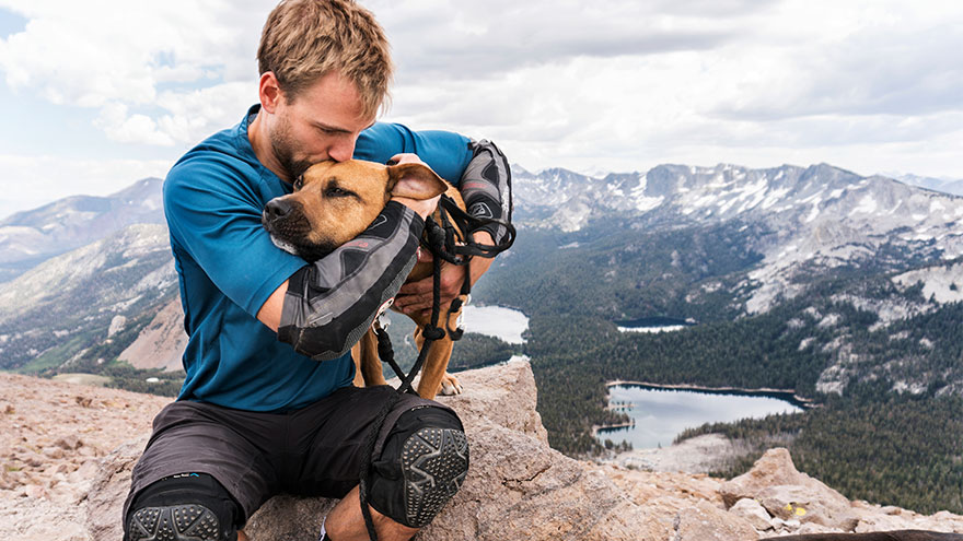
8 Local Hiking Trails You Need to Explore
Need fresh hiking trails? These hiking trails offer new views, a different route or the motivation you need to get outside. Of course, whatever you’re looking for this summer, these trails were made for sunshine in Reno-Tahoe. Easy Hiking Trails Oxbow Nature Study Area Nature Trail Location: 3100 Dickerson Road, at the Truckee River. Parking: There is a parking lot onsite. Time Out and Back: 30 minutes Items to Bring: Water, sunscreen and a hat. Although this loop is just under one mile, it’s the perfect escape in the heart of Reno. And this riverside trail is accessible for all skill levels. Bird watcher? Certainly, keep an eye out for black-crowned night herons, red-shouldered hawks, mule deer, beavers and more wildlife in the area. Tahoe-Pyramid Bikeway – Sections 2 to 4 Location: West Reno to Sparks Parking: Woodland Drive, Crissie Caughlin Park, Idlewild Park, 1st Street, Rock Park and Spice Island Drive. Time Out and Back: 2-4 hours (each section, out and back) Items to Bring: Water, sunscreen and a hat. From west Reno to Sparks, this paved portion of the trail stretches more than 8 miles. And it is easy to find as it runs along the Truckee River. As one of the easiest hiking trails in the region, it includes numerous parking access points and you can walk as long or short as you desire. In particular, one great route is from Rock Park on S. Rock Boulevard to Cottonwood Park on Spice Island Drive in Sparks. It’s an easy walk for all hiking levels. Notably many evening hikers explore this area to view the bats living under the McCarran Bridge. Additionally, an array of birds and river views can also be found along this enjoyable path. For maps for sections of this path, visit Tahoe-Pyramid Bikeway’s website. Cave Rock Hiking Trail Location: South Lake Tahoe; turn right on Cave Rock Drive from Highway 50, just prior to the tunnel. Parking: Park on Cave Rock Drive. Time Out and Back: 30 minutes Items to Bring: Water and sunscreen. Not only does this short trail have breathtaking views of Lake Tahoe, but it is also meaningful. Chiefly the rock was created more than three million years ago. Equally important, it is still considered sacred to the Washoe Native Americans. Also, leashed dogs are welcome on the trail. Moderate Hiking Trails Steamboat Ditch Trail Location: To get to the trailhead, take Mayberry Drive in west Reno. Then turn south on Plateau Road and right onto Woodchuck Circle. Parking: There is a dirt area for limited parking. Time Out and Back: 3-5 hours Items to Bring: Water, layers, sunscreen and a hat. Of all the hiking trails listed, this one offers some of the best views of downtown Reno and the surrounding hillsides. Built by Chinese laborers in the late 1870s, the Steamboat Ditch is the longest ditch in the Truckee Meadows region. In fact, the water serves as a vital source for ranchers and farmers south of Reno. First, start behind the Patagonia in northwest Reno at the Tom Cooke Trail or park off of Woodchuck Circle. Next head west to find the “Hole in the Wall.” Surprisingly this is a tunnel engineered through the hill, so the ditch could supply water to the Truckee Meadows. This hike is a little over 8 miles with the halfway point just under 4½ miles. With this in mind, if you’re thinking of hiking with your four-legged friend, remember to bring your leash because rattlesnakes can be spotted. Usually there’s also little shade, so plan accordingly by bringing a hat and dressing in layers. Thomas Creek Trail Location: Head out on Mt. Rose Highway going west to Timberline Road. Then drive 1.3 miles past the end of the pavement, stay on Timberline and you will see the trail head on your left shortly after you cross the bridge. Parking: There is a paved parking area on Timberline Drive. Time Out to Back: 2-6 hours Items to Bring: Water, layers, food and a phone with GPS or map. Definitely put he Thomas Creek Trail on your hiking trails list. Located off of Mt. Rose Highway, it is a very scenic hike winding along Thomas Creek into a Jeffrey pine forest. You may choose to hike to what appears to be the end of the trail (where it meets the road) or continue further up for 1/8 of a mile into the Mt. Rose Wilderness. Hiking up the trail to the creek crossing, and then taking the dirt road back down is a great way to see the entire canyon. While this hiking trail is closer to 5 miles, it can be shortened by turning around at any point. Another option is to look for signs to turn off the Thomas Creek Trail at the junction for Dry Pond Loop. Dry Pond is a 4½-mile, out and back hiking trail from the Timberline parking lot. Ultimately you may see a pond or hilltop meadow, depending on the season and weather. Overall it is possible to go anywhere from 2 to 6 miles (or more), based on what you choose to hike. The gain along the creek is minimal, with an 800-foot gain at the top part of the trail. In particular, watch for mountain bikers, as this is also a very popular biking trail. Hunter Creek Trail Location: Go west on Mayberry Drive to Plateau Road. Then turn left and go up the hill to Woodchuck Drive. Lastly, turn right and follow Woodchuck to the hiking trail head. Parking: Paved parking on Woodchuck Drive with a bathroom and benches. Time Out and Back: 2-5 hours Items to Bring: Water, layers, a snack, sturdy shoes and sunscreen. The Hunter Creek trail is about a 7-mile day hike with a little over 1,000 feet of overall gain leading to a waterfall. Ultimately it’s totally worth the trip! This hiking trail winds up Hunter Canyon through sagebrush, Jeffrey pines and interesting rock formations. The waterfall is a great place to sit on shaded logs and enjoy lunch. This trek is very rocky and narrow at times, so good trail shoes are recommended. Furry friends should also be leashed, as rattlesnakes and wildlife are common along the trail. Difficult Hiking Trails Hidden Valley Loop Location: Hidden Valley Regional Park; drive east on Pembroke Drive and turn left on Parkway Drive. The park is at the end of the road. Parking: Park on the east side of the park, closest to the hills. Time Out and Back: 3-6 hours Items to Bring: Water, sunscreen, shoes with good traction and a lunch or snack. Overall this 6-mile loop has about 1,800 feet of gain and is located east of Hidden Valley. We recommend starting the hike from Hidden Valley Regional Park. First, head southeast on a dirt road and then turn east onto a very steep trail that winds over red dirt for about a half mile. In fact, this is the steepest part and it’s a leg burner. Once you get past the climb, the trail gradient decreases. Then you wind along the south side of a big bowl lined with pinyon pine and juniper trees. The hiking trail continues up to the ridge line where there are incredible views of the Truckee Meadows and Mt. Rose. You can hike back down from this point, but it is best to continue on the trail along the ridge line to where it isn’t as steep with incredible views. Frequently you may see wild horses while hiking in this area. Mount Tallac Location: Southwestern side of Lake Tahoe, between Emerald Bay and Camp Richardson. Turn south on Mt. Tallac Road from Highway 89. Parking: Follow Mt. Tallac Road to the parking lot. Time Out and Back: 6 hours Items to Bring: Water, layers, lunch or snacks, sunglasses, hat, sturdy shoes and sunscreen. Definitely a big hike with an even bigger reward — an incredible view of the Desolation Wilderness and Lake Tahoe. This hiking trail is 10.5 miles out and back with a 3,500-foot elevation gain. If you’d like to explore the area without the 6-hour commitment, hike 1.7 miles out to Floating Island Lake or 2.3 miles out to Cathedral Lake. Day use permits are required and you can fill one out for free at the trailhead.